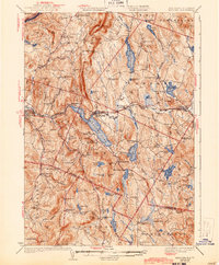
1932 Map of Mascoma
USGS Topo · Published 1943About this map
Lower Shaker Village and Upper Shaker Village anchor the western shore of Mascoma Lake, reflecting the legacy of Shaker communal life in Grafton County during the early 20th century. This 1927 survey, updated with aerial photography, reveals a landscape of dispersed agricultural settlements connected by the Boston and Maine railroad, which follows the Mascoma River through Enfield and West Canaan. The terrain is defined by significant ridges like Shaker Mountain and Croydon Mountain, which separated the small valleys and dictated the placement of local school districts.
Find a feature on this map
104 named features on this map. Tap any name to fly to it.
Don’t see what you’re looking for? This feature index may not catch every label — zoom into the map to look around manually.
Map Details
Editions of this 1932 Mascoma Map
5 editions found

Other maps of this area

1896 · Strafford
USGS Topo · 1:62,500

1902 · Sunapee
USGS Topo · 1:62,500

1905 · Sunapee
USGS Topo · 1:62,500

1906 · Hanover
USGS Topo · 1:62,500

1907 · Sunapee
USGS Topo · 1:62,500

1908 · Hanover
USGS Topo · 1:62,500

1926 · Claremont
USGS Topo · 1:62,500

1927 · Cardigan
USGS Topo · 1:62,500

1927 · Mascoma
USGS Topo · 1:62,500

1928 · Mount Kearsarge
USGS Topo · 1:62,500