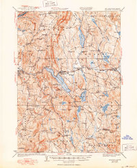
1932 Map of Mascoma
USGS Topo · Published 1950About this map
Lower Shaker Village and Upper Shaker Village occupy the western shores of Mascoma Lake, marking a distinct chapter of communal history in this part of Grafton County. The landscape is defined by the high ridges of Moose Mountain and Shaker Mountain, which hem in a network of ponds and narrow valleys. This 1927 survey, updated with Air Corps aerial photography, illustrates a rugged terrain where small settlements like Enfield Center and Canaan Street are connected by the Boston and Maine railroad line as it follows the Mascoma River. Numerous rural institutions are documented across the hills, from the remote Height of Land School to the Methodist Hill School. The presence of the Hanover Reservoirs and several clusterings of neighborhood schools, such as the Etna Highlands School, reflects the decentralized settlement patterns of the early twentieth century before modern consolidation.
Find a feature on this map
110 named features on this map. Tap any name to fly to it.
Don’t see what you’re looking for? This feature index may not catch every label — zoom into the map to look around manually.
Map Details
Editions of this 1932 Mascoma Map
5 editions found

Other maps of this area

1896 · Strafford
USGS Topo · 1:62,500

1902 · Sunapee
USGS Topo · 1:62,500

1905 · Sunapee
USGS Topo · 1:62,500

1906 · Hanover
USGS Topo · 1:62,500

1907 · Sunapee
USGS Topo · 1:62,500

1908 · Hanover
USGS Topo · 1:62,500

1926 · Claremont
USGS Topo · 1:62,500

1927 · Cardigan
USGS Topo · 1:62,500

1927 · Mascoma
USGS Topo · 1:62,500

1928 · Mount Kearsarge
USGS Topo · 1:62,500