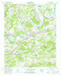
1966 Map of Mascot
USGS Topo · Published 1978About this map
The Holston River carves a winding path through this East Tennessee landscape, creating dramatic bends like Big Bend and Mitchell Bend while supporting a series of islands including McBee Island and Byerley Island. Industrial activity centers on the settlement of Mascot, where Zinc mining operations and a large Tailings pond reflect the local mineral economy during the mid-1960s. The Southern Railway and the Andrew Johnson Highway serve as the primary east-west transportation corridors, connecting Strawberry Plains with neighboring rural communities like Trentville and Thorn Grove.
Find a feature on this map
91 named features on this map. Tap any name to fly to it.
Don’t see what you’re looking for? This feature index may not catch every label — zoom into the map to look around manually.
Map Details
Editions of this 1966 Mascot Map
4 editions found
Other maps of this area

1886 · Knoxville
USGS Topo · 1:125,000

1892 · Knoxville
USGS Topo · 1:125,000

1894 · Knoxville
USGS Topo · 1:125,000

1895 · Knoxville
USGS Topo · 1:125,000

1897 · Maynardville
USGS Topo · 1:125,000

1900 · Maynardville
USGS Topo · 1:125,000

1901 · Knoxville
USGS Topo · 1:125,000

1935 · Luttrell
USGS Topo · 1:24,000

1935 · Mascot
USGS Topo · 1:24,000

1935 · Knoxville
USGS Topo · 1:48,000