
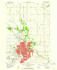
1959 Map of Mason City
USGS Topo · Published 1960About this map
Mason City serves as the industrial and transportation hub of North Central Iowa in this late 1950s survey. The city's landscape is defined by its deep relationship with local geology, evidenced by the numerous quarries, claypits, and kilns that flank its western and northern borders. These resources fueled a robust manufacturing economy, while the Winnebago River and Willow Creek provided the essential water network for the growing municipality.
Find a feature on this map
51 named features on this map. Tap any name to fly to it.
Don’t see what you’re looking for? This feature index may not catch every label — zoom into the map to look around manually.
Map Details
Editions of this 1959 Mason City Map
2 editions found
Other maps of this area

1954 · Mason City
USGS Topo · 1:250,000

1957 · Mason City
USGS Topo · 1:250,000

1958 · Mason City
USGS Topo · 1:250,000

1959 · Mason City
USGS Topo · 1:62,500

1959 · Nora Springs
USGS Topo · 1:24,000

1959 · Mason City SE
USGS Topo · 1:24,000

1959 · Hanford
USGS Topo · 1:24,000

1972 · Manly
USGS Topo · 1:24,000

1972 · Burchinal
USGS Topo · 1:24,000
1972 · Clear Lake East
USGS Topo · 1:24,000