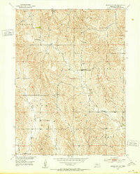
1951 Map of Mason City NW
USGS Topo · Published 1953About this map
The Loup River and its network of tributaries define this mid-century Custer County landscape, captured just as the Department of the Interior was developing the Missouri River Basin. This survey illustrates a rural Nebraska structured by small, localized educational and religious hubs. One can trace the distribution of community anchors like First Budell Ch and a series of district schoolhouses including Hawk Sch, Ash Grove Sch, McIntosh Sch, and Battle Bend Sch. The terrain is marked by numerous Windmill sites, essential for the ranching and farming operations that relied on the waters of Elk Creek, West Box Elder Creek, and East Box Elder Creek. The map also delineates civil boundaries such as Ansley, Berwyn, Algernon, and Elk Creek, showing how these townships organized the land during the early 1950s.
Find a feature on this map
15 named features on this map. Tap any name to fly to it.
Don’t see what you’re looking for? This feature index may not catch every label — zoom into the map to look around manually.
Map Details
Editions of this 1951 Mason City NW Map
3 editions found
Other maps of this area

1951 · Ansley
USGS Topo · 1:24,000

1951 · Broken Bow SE
USGS Topo · 1:24,000

1951 · Eddyville NE
USGS Topo · 1:24,000

1951 · Mason City SW
USGS Topo · 1:24,000

1951 · Eddyville
USGS Topo · 1:24,000

1951 · Mason City NW
USGS Topo · 1:24,000

1951 · Mason City
USGS Topo · 1:24,000

1951 · Ansley SE
USGS Topo · 1:24,000

1951 · Mason City SE
USGS Topo · 1:24,000

1955 · Broken Bow
USGS Topo · 1:250,000