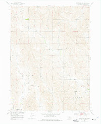
1951 Map of Mason City NW
USGS Topo · Published 1976About this map
The rural prairie landscape of Custer County unfolds across this mid-century survey, defined by the winding paths of Elk Creek and Cat Creek. This map documents a decentralized agrarian society during the development of the Missouri River Basin, where small district schools served as the primary social anchors for dispersed farmsteads. These institutions, including Hawk Sch, Ash Grove Sch, McIntosh Sch, and Battle Bend Sch, are positioned along the sections of Ansley, Berwyn, and Algernon. Near the southern boundary, the First Eudell Ch stands as a focal point for the community. The presence of numerous Windmill labels throughout the township indicates the vital reliance on groundwater for livestock and domestic use in this open Nebraska terrain, where East Box Elder Creek and West Box Elder Cr carve shallow valleys through the Loess Hills.
Find a feature on this map
16 named features on this map. Tap any name to fly to it.
Don’t see what you’re looking for? This feature index may not catch every label — zoom into the map to look around manually.
Map Details
Editions of this 1951 Mason City NW Map
3 editions found
Other maps of this area

1951 · Ansley
USGS Topo · 1:24,000

1951 · Broken Bow SE
USGS Topo · 1:24,000

1951 · Eddyville NE
USGS Topo · 1:24,000

1951 · Mason City SW
USGS Topo · 1:24,000

1951 · Eddyville
USGS Topo · 1:24,000

1951 · Mason City NW
USGS Topo · 1:24,000

1951 · Mason City
USGS Topo · 1:24,000

1951 · Ansley SE
USGS Topo · 1:24,000

1951 · Mason City SE
USGS Topo · 1:24,000

1955 · Broken Bow
USGS Topo · 1:250,000