
1954 Map of Mason
USGS Topo · Published 1954About this map
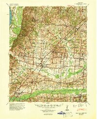
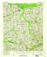
The Loosahatchie River and its accompanying drainage canals, such as the Indian Drainage Canal, dominate this West Tennessee landscape at the intersection of Tipton, Shelby, and Fayette counties. The region is characterized by a dense network of small rural communities and social hubs, including the notable Dunlap Orphanage and the Mason Hall Ch. Transport and trade are anchored by the Louisville and Nashville Railroad, which connects the towns of Arlington, Braden, and Mason. The map reveals a high concentration of schools and churches that served as the backbone of mid-century rural life, with family and community names preserved in sites like Barret Chapel Sch, Chickasaw Fields Sch, and the Mt Tipton Ch & Cem. The transition from natural waterways to engineered drainage reflects the agricultural priorities of the era, visible in the straightening of Beaver Creek and Little Cypress Creek.
Find a feature on this map
104 named features on this map. Tap any name to fly to it.
Don’t see what you’re looking for? This feature index may not catch every label — zoom into the map to look around manually.
Map Details
Editions of this 1954 Mason Map
This is the sole edition of this map. No revisions or reprints were ever made.
Other maps of this area
1942 · Millington
USGS Topo · 1:62,500

1943 · Collierville
USGS Topo · 1:62,500
1949 · Moscow
USGS Topo · 1:62,500
1952 · Stanton
USGS Topo · 1:24,000
1952 · Lambert
USGS Topo · 1:24,000
1952 · Stanton
USGS Topo · 1:62,500

1953 · Collierville
USGS Topo · 1:50,000

1956 · Blytheville
USGS Topo · 1:250,000

1959 · Blytheville
USGS Topo · 1:250,000
1960 · Bartlett
USGS Topo · 1:62,500