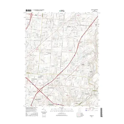
2016 Map of Mason
USGS Topo · Published 2016About this map
Mason and the surrounding suburbs of Sharonville and Loveland define this corridor in 2016, where residential growth meets established landmarks at the junction of three counties. The map illustrates a landscape of modern expansion, from the campus of The Art Institute of Ohio-Cincinnati to the winding course of the Little Miami River along the eastern edge. Settlement patterns follow historic markers such as Sixteen Mile Stand and Twenty Mile Stand, names that recall the stagecoach era along the road to Cincinnati.
Find a feature on this map
47 named features on this map. Tap any name to fly to it.
Don’t see what you’re looking for? This feature index may not catch every label — zoom into the map to look around manually.
Map Details
Editions of this 2016 Mason Map
This is the sole edition of this map. No revisions or reprints were ever made.
Other maps of this area

1898 · East Cincinnati
USGS Topo · 1:62,500

1904 · Mason
USGS Topo · 1:62,500

1906 · Mason
USGS Topo · 1:62,500

1914 · East Cincinnati
USGS Topo · 1:62,500

1914 · Batavia
USGS Topo · 1:48,000

1914 · Morrow
USGS Topo · 1:62,500

1916 · Batavia
USGS Topo · 1:62,500

1916 · Morrow
USGS Topo · 1:62,500

1953 · Goshen
USGS Topo · 1:24,000
1953 · Madeira
USGS Topo · 1:24,000