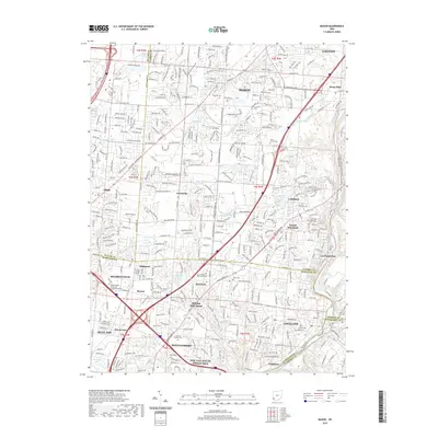
2019 Map of Mason
USGS Topo · Published 2019About this map
Mason and its surrounding suburbs in Warren, Hamilton, Butler, and Clermont counties are shown during a period of significant residential expansion and connectivity. The landscape is defined by the Little Miami River corridor along the eastern edge, which hosts the N Country National Scenic Trail. This modern survey illustrates how historically distinct settlements like Socialville, Twenty Mile Stand, and Sixteen Mile Stand have become integrated into the larger metropolitan fabric while maintaining their local identities. Genealogists will find numerous burial grounds preserved amidst this growth, including the Rose Hill Cem and the Cline Family Cem. The presence of educational institutions such as The Art-Institute of Ohio-Cincinnati and Galen College of Nursing - Cincinnati Campus highlights the area's transition into a regional hub for specialized training and services.
Find a feature on this map
59 named features on this map. Tap any name to fly to it.
Don’t see what you’re looking for? This feature index may not catch every label — zoom into the map to look around manually.
Map Details
Editions of this 2019 Mason Map
This is the sole edition of this map. No revisions or reprints were ever made.
Other maps of this area

1898 · East Cincinnati
USGS Topo · 1:62,500

1904 · Mason
USGS Topo · 1:62,500

1906 · Mason
USGS Topo · 1:62,500

1914 · East Cincinnati
USGS Topo · 1:62,500

1914 · Batavia
USGS Topo · 1:48,000

1914 · Morrow
USGS Topo · 1:62,500

1916 · Batavia
USGS Topo · 1:62,500

1916 · Morrow
USGS Topo · 1:62,500

1953 · Goshen
USGS Topo · 1:24,000
1953 · Madeira
USGS Topo · 1:24,000