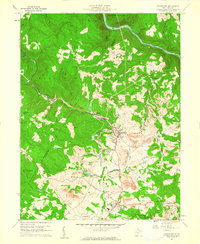
1960 Map of Masontown
USGS Topo · Published 1961About this map
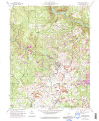
Masontown and the surrounding coal-country plateau of Preston and Monongalia counties are defined here by a dense industrial and transport network. The Baltimore and Ohio railroad corridor tracks along Deckers Creek, serving the coal-loading operations at Bretz and Cascade. This 1960 field-checked survey captures the area's complex settlement patterns, from the planned subsistence community of Arthurdale to smaller named hamlets like Rohr and Guseman. To the north, the terrain drops sharply toward the Cheat River, where the Coopers Rock State Forest overlooks Beaverhole and the Cheat View overlook. Cultural landmarks including the Sturgiss Sch, Zinn Chapel, and a Drive-in Theater near Dillan Creek offer specific touchpoints for local historians and genealogists researching the mid-century landscape of West Virginia's coal fields.
Find a feature on this map
54 named features on this map. Tap any name to fly to it.
Don’t see what you’re looking for? This feature index may not catch every label — zoom into the map to look around manually.
Map Details
Editions of this 1960 Masontown Map
5 editions found
Other maps of this area

1886 · St. George
USGS Topo · 1:125,000

1891 · St. George
USGS Topo · 1:125,000

1902 · Morgantown
USGS Topo · 1:62,500

1904 · Bruceton
USGS Topo · 1:62,500

1907 · Thornton
USGS Topo · 1:62,500

1907 · Kingwood
USGS Topo · 1:62,500

1925 · Kingwood
USGS Topo · 1:62,500

1925 · Morgantown
USGS Topo · 1:62,500

1926 · Thornton
USGS Topo · 1:62,500

1926 · Bruceton
USGS Topo · 1:62,500