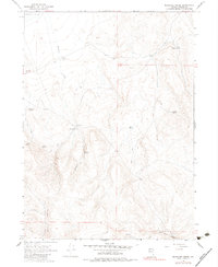
1966 Map of Massacre Creek
USGS Topo · Published 1983About this map
Massacre Ranch sits as a lonely outpost within the high desert landscape of northwestern Nevada, centered on the drainage of Massacre Creek. The importance of water in this arid terrain is evidenced by the density of named water sources, ranging from the seasonally variable Middle Lake to a network of isolated springs including Emigrant Spring, Willow Spring, and Coyote Spring. These features suggest the historic movement of people and livestock through the region long before modern infrastructure reached this corner of Washoe County.
Find a feature on this map
18 named features on this map. Tap any name to fly to it.
Don’t see what you’re looking for? This feature index may not catch every label — zoom into the map to look around manually.
Map Details
Editions of this 1966 Massacre Creek Map
2 editions found
Other maps of this area

1889 · Long Valley
USGS Topo · 1:250,000

1954 · Vya
USGS Topo · 1:250,000

1958 · Vya
USGS Topo · 1:250,000

1962 · Vya
USGS Topo · 1:250,000

1966 · Badger Mtn NW
USGS Topo · 1:24,000

1966 · Massacre Lake NW
USGS Topo · 1:24,000

1966 · Massacre Lake
USGS Topo · 1:24,000

1966 · Nut Mountain
USGS Topo · 1:24,000

1966 · Massacre Creek
USGS Topo · 1:24,000

1966 · Painted Point
USGS Topo · 1:24,000