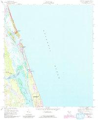
1956 Map of Matanzas Inlet
USGS Topo · Published 1992About this map
Ft Matanzas Nat Mon stands as a sentinel over the shifting sands of the Matanzas Inlet on this 1950s survey, revised in the early 1990s. The landscape is defined by the narrow barrier of Anastasia Island and the intricate channels of the Matanzas River and the Intracoastal Waterway. This coastal stretch showcases a transition from the colonial defense site at Rattlesnake Island to the residential development seen at Summer Haven. Further south, the map documents significant protected lands, including the Faver-Dykes State Park and Washington Oaks State Gardens. The intricate drainage systems of Pellicer Creek, Stiles Creek, and Hulett Branch illustrate the wetland geography of the St Johns and Flagler county border, where an Artesian Well points to the area's groundwater reliance during this mid-century period.
Find a feature on this map
21 named features on this map. Tap any name to fly to it.
Don’t see what you’re looking for? This feature index may not catch every label — zoom into the map to look around manually.
Map Details
Editions of this 1956 Matanzas Inlet Map
4 editions found
Other maps of this area

1927 · Matanzas
USGS Topo · 1:48,000

1937 · Crescent Beach
USGS Topo · 1:24,000

1937 · Dinner Island
USGS Topo · 1:48,000

1943 · St. Augustine
USGS Topo · 1:62,500

1943 · Dinner Island
USGS Topo · 1:62,500

1943 · Matanzas
USGS Topo · 1:62,500

1944 · Dinner Island
USGS Topo · 1:62,500

1944 · Matanzas
USGS Topo · 1:62,500

1954 · Daytona Beach
USGS Topo · 1:250,000

1956 · Dinner Island NE
USGS Topo · 1:24,000