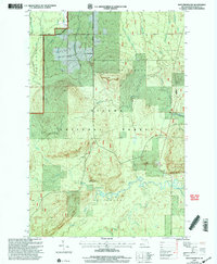
1999 Map of Matchwood
USGS Topo · Published 2004About this map
Ottawa National Forest dominates this section of Michigan's western Upper Peninsula, characterized by a complex drainage network that feeds into the Ontonagon River. The landscape is defined by the steep relief of the Ontonagon range, where Cascade Falls marks a significant drop in the topography south of the Bergland Ranger District. While much of the area remained heavily forested at the close of the century, the map reveals a history of resource extraction and transit through features like the Gravel Pit and the path of Victoria Road.
Find a feature on this map
31 named features on this map. Tap any name to fly to it.
Don’t see what you’re looking for? This feature index may not catch every label — zoom into the map to look around manually.
Map Details
Editions of this 1999 Matchwood Map
2 editions found
Other maps of this area

1949 · Matchwood NW
USGS Topo · 1:24,000

1949 · Bergland NE
USGS Topo · 1:24,000

1952 · Thayer
USGS Topo · 1:62,500

1955 · Marenisco
USGS Topo · 1:62,500

1956 · Bergland NE
USGS Topo · 1:24,000

1956 · Bergland
USGS Topo · 1:62,500

1956 · Matchwood NW
USGS Topo · 1:24,000

1956 · Matchwood
USGS Topo · 1:62,500

1958 · Iron River
USGS Topo · 1:250,000

1960 · Iron River
USGS Topo · 1:250,000