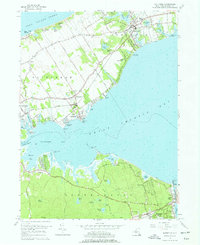
1956 Map of Mattituck
USGS Topo · Published 1977About this map
Mattituck and the surrounding north and south forks of Long Island define this 1956 landscape, where the Long Island Railroad cuts through a mosaic of agricultural fields and coastal inlets. The terrain transition between the Long Island Sound to the north and the expansive Great Peconic Bay to the south reveals a complex water system including Mattituck Creek and Laurel Lake. This mid-century survey captures the region's character as a retreat and maritime hub, evidenced by Camp Malloy, Camp Immaculate, and the Mattituck Park District Beach. To the south, settlements like Flanders and Hampton Bays are linked by the Montauk Highway near Canoe Place, while interior landmarks such as Northville Cem and various small ponds like Sears Pond and Penny Pond provide fine-grained detail for local historians and genealogists.
Find a feature on this map
71 named features on this map. Tap any name to fly to it.
Don’t see what you’re looking for? This feature index may not catch every label — zoom into the map to look around manually.
Map Details
Editions of this 1956 Mattituck Map
4 editions found

Other maps of this area

1903 · Sag Harbor
USGS Topo · 1:62,500

1903 · Riverhead
USGS Topo · 1:62,500

1904 · Sag Harbor
USGS Topo · 1:62,500

1904 · Shelter Island
USGS Topo · 1:62,500

1904 · Riverhead
USGS Topo · 1:62,500

1943 · Riverhead
USGS Topo · 1:62,500

1947 · Mattituck
USGS Topo · 1:24,000

1947 · Mattituck Hills
USGS Topo · 1:24,000

1947 · Southold
USGS Topo · 1:24,000

1947 · Southampton
USGS Topo · 1:24,000