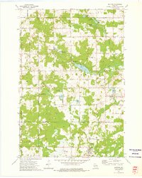
1973 Map of Mattoon
USGS Topo · Published 1976About this map
The boundary between Langlade and Shawano counties cuts through this 1970s landscape, where the village of Mattoon and the smaller settlement of Phlox anchor a region defined by its glacial lakes and river systems. To the south, the lumber and rail legacy is visible in the Old Railroad Grade passing near the Shelley Landing Field. This era saw significant land management for recreation and conservation, evidenced by the Demlow Lake State Fishery Area and Deneault Springs State Fishery Area. Further north, a network of family-named water bodies like Thompson Lake and Meyer Lake are interspersed with local landmarks like Crestwood Sch and the Norwood Cem. The winding West Branch Red River connects several smaller lakes, such as Phlox Lake, illustrating the drainage patterns that shaped the local economy and settlement locations.
Find a feature on this map
55 named features on this map. Tap any name to fly to it.
Don’t see what you’re looking for? This feature index may not catch every label — zoom into the map to look around manually.
Map Details
Editions of this 1973 Mattoon Map
2 editions found
Other maps of this area

1952 · Antigo
USGS Topo · 1:48,000

1952 · White Lake
USGS Topo · 1:48,000

1954 · Wittenberg
USGS Topo · 1:48,000

1954 · Gresham
USGS Topo · 1:48,000

1954 · Iron Mountain
USGS Topo · 1:250,000

1955 · Green Bay
USGS Topo · 1:250,000

1959 · Iron Mountain
USGS Topo · 1:250,000

1964 · Wittenberg
USGS Topo · 1:62,500

1964 · Gresham
USGS Topo · 1:62,500
1973 · Antigo
USGS Topo · 1:24,000