
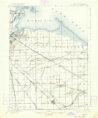
1900 Map of Maumee Bay
USGS Topo · Published 1921About this map
Maumee Bay and the shoreline of Lake Erie dominate this turn-of-the-century landscape, revealing a complex network of industrial and transport infrastructure where the Maumee River meets the lake. In Oregon and Jerusalem townships, the presence of numerous Oil Wells and Coke Ovens indicates the early energy economy of the region. The map captures a high density of rail lines, including the Lake Shore and Michigan Southern R. R. and the interurban Toledo and Norwalk Electric Line, which connected emerging hubs like Ironville and Millbury.
Find a feature on this map
60 named features on this map. Tap any name to fly to it.
Don’t see what you’re looking for? This feature index may not catch every label — zoom into the map to look around manually.
Map Details
Editions of this 1900 Maumee Bay Map
2 editions found
Other maps of this area

1900 · Toledo
USGS Topo · 1:62,500

1900 · Oak Harbor
USGS Topo · 1:62,500

1901 · Bowling Green
USGS Topo · 1:62,500

1901 · Fremont
USGS Topo · 1:62,500

1901 · Elmore
USGS Topo · 1:62,500

1903 · Bowling Green
USGS Topo · 1:62,500

1903 · Fremont
USGS Topo · 1:62,500

1903 · Elmore
USGS Topo · 1:62,500

1912 · Monroe
USGS Topo · 1:62,500

1912 · Dundee
USGS Topo · 1:62,500