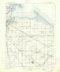
1900 Map of Maumee Bay
USGS Topo · Published 1934About this map
Maumee Bay and the shoreline of Lake Erie dominate this turn-of-the-century landscape, where a dense network of steam and electric railways connects emerging industrial outposts with established rural villages. The area east of the Maumee River is marked by early extraction and manufacturing, including clusters of Oil Wells and Coke Ovens near Curtice. The transport infrastructure is remarkably complex for the era, featuring the Wheeling and Lake Erie Railway and specialized lines like the Toledo Woodville and Genoa Electric Power Railway. From the marshy reaches of Ward Canal to the settled streets of Genoa, the map documents a region in transition, balancing coastal commerce with interior development in townships like Oregon and Jerusalem. Small settlements and post offices such as Shepardsville Bono P.O. and Millbury provide critical location data for genealogists tracing family roots in this corner of Northwest Ohio.
Find a feature on this map
60 named features on this map. Tap any name to fly to it.
Don’t see what you’re looking for? This feature index may not catch every label — zoom into the map to look around manually.
Map Details
Editions of this 1900 Maumee Bay Map
2 editions found
Other maps of this area

1900 · Maumee Bay
USGS Topo · 1:62,500

1900 · Toledo
USGS Topo · 1:62,500

1900 · Oak Harbor
USGS Topo · 1:62,500

1901 · Bowling Green
USGS Topo · 1:62,500

1901 · Fremont
USGS Topo · 1:62,500

1901 · Elmore
USGS Topo · 1:62,500

1903 · Bowling Green
USGS Topo · 1:62,500

1903 · Fremont
USGS Topo · 1:62,500

1903 · Elmore
USGS Topo · 1:62,500

1912 · Monroe
USGS Topo · 1:62,500