
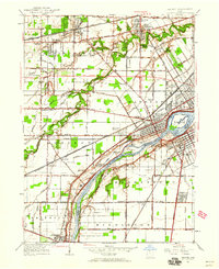
1951 Map of Maumee
USGS Topo · Published 1952About this map
Maumee River serves as the central artery for this landscape, dividing Lucas and Wood counties and defining the development of Maumee and Perrysburg. The map reveals a dense layer of military and frontier history, notably preserved at Fort Miami, Fort Meigs, and Fallen Timber State Park. Near the river, Turkey Foot Rock stands as a specific landmark of the region's early heritage. The mid-century era is characterized by an extensive network of railroads including the Wabash RR and the Baltimore and Ohio RR, which parallel the river and support smaller clusters like Waterville and Holland. Away from the riverbank, the land is partitioned by a grid of named drainage features such as Cairl Ditch and Scott Ditch, reflecting the conversion of local wetlands into productive agricultural and residential land. Suburban growth is evident in developments like Monclova Gardens and the Heather Downs Country Club.
Find a feature on this map
63 named features on this map. Tap any name to fly to it.
Don’t see what you’re looking for? This feature index may not catch every label — zoom into the map to look around manually.
Map Details
Editions of this 1951 Maumee Map
2 editions found
Other maps of this area

1900 · Toledo
USGS Topo · 1:62,500

1901 · Bowling Green
USGS Topo · 1:62,500

1903 · Bowling Green
USGS Topo · 1:62,500

1909 · Mc Clure
USGS Topo · 1:62,500

1911 · Swanton
USGS Topo · 1:62,500

1914 · Swanton
USGS Topo · 1:62,500

1934 · Rossford
USGS Topo · 1:24,000

1935 · Grand Rapids
USGS Topo · 1:24,000

1935 · Whitehouse
USGS Topo · 1:24,000

1935 · Maumee
USGS Topo · 1:24,000