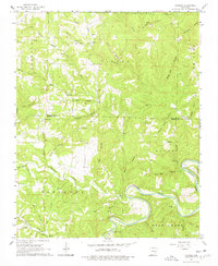
1966 Map of Maumee
USGS Topo · Published 1978About this map
The Buffalo River snakes across the southern portion of this mid-1960s survey, defining a landscape marked by deep hollows and high ridges along the border of Marion and Searcy Counties. The community of Maumee sits near the riverbanks, served by the Maumee Crossing and surrounded by narrow drainages like Green Haw Hollow and Maumee Hollow. To the west, the winding course of Tomahawk Creek flows past Tomahawk Ch, while the northern reaches include local landmarks such as Community Hall and the Burns Cem.
Find a feature on this map
46 named features on this map. Tap any name to fly to it.
Don’t see what you’re looking for? This feature index may not catch every label — zoom into the map to look around manually.
Map Details
Editions of this 1966 Maumee Map
3 editions found
Other maps of this area

1892 · Marshall
USGS Topo · 1:125,000

1893 · Yellville
USGS Topo · 1:125,000

1894 · Marshall
USGS Topo · 1:125,000

1901 · Marshall
USGS Topo · 1:125,000

1903 · Yellville
USGS Topo · 1:125,000

1905 · Yellville
USGS Topo · 1:125,000

1929 · Yellville
USGS Topo · 1:125,000

1939 · Snowball
USGS Topo · 1:62,500

1941 · Snowball
USGS Topo · 1:62,500

1942 · Snowball
USGS Topo · 1:62,500