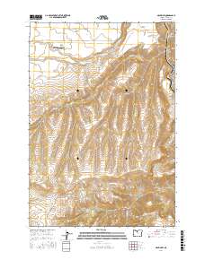
2017 Map of Maupin SW
USGS Topo · Published 2017About this map
Juniper Flat dominates the northern reaches of this landscape, where the plateau gives way to the deep, winding incision of Devil Canyon. The terrain transitions from the open grazing lands of Natural Pasture into the rising elevations of the Mutton Mountains to the south. Water management is a central theme of the northern geography, evidenced by the Kelly Lateral and several drainages including Wapinitia Cr and Rice Cr that flow toward the eastern boundary. The Nelson Ranch Airport serves as a lone modern landmark in this expansive territory. Along the eastern edge, the Deschutes River carves a significant corridor, accompanied by Deschutes River Rd, illustrating how the waterway dictates the primary transport and topographic relief in this part of Wasco County.
Find a feature on this map
34 named features on this map. Tap any name to fly to it.
Don’t see what you’re looking for? This feature index may not catch every label — zoom into the map to look around manually.
Map Details
Editions of this 2017 Maupin SW Map
This is the sole edition of this map. No revisions or reprints were ever made.
Other maps of this area

1928 · Madras
USGS Topo · 1:125,000

1930 · Dufur
USGS Topo · 1:125,000

1931 · Madras
USGS Topo · 1:125,000

1934 · Dufur
USGS Topo · 1:125,000

1953 · The Dalles
USGS Topo · 1:250,000

1955 · Bend
USGS Topo · 1:250,000

1956 · The Dalles
USGS Topo · 1:250,000

1957 · Bend
USGS Topo · 1:250,000

1957 · The Dalles
USGS Topo · 1:250,000

1958 · Bend
USGS Topo · 1:250,000