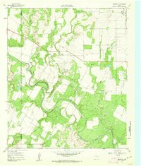
1961 Map of Maverick
USGS Topo · Published 1962About this map
The Colorado River meanders through the central terrain of this early 1960s survey, marking a distinct boundary between Coke and Runnels counties. The small settlement of Maverick serves as a focal point for local history, supported by the Maverick Cem and Castleberry Cem. This landscape is defined by its drainage network, where Oak Creek and Juniper Creek feed into the primary river channel, and a significant Pipeline cuts across the northern cattle and ranch land. In the northwest, the community of Norton and its associated Norton Cem stand near a scatter of oil production sites, including an Oil Well, illustrating the era's reliance on both agriculture and petroleum. To the south, the Brookshier Ch remains a notable landmark along the rural roads, representing the social core of this sparsely populated ranching region.
Find a feature on this map
17 named features on this map. Tap any name to fly to it.
Don’t see what you’re looking for? This feature index may not catch every label — zoom into the map to look around manually.
Map Details
Editions of this 1961 Maverick Map
2 editions found
Other maps of this area

1891 · Hayrick
USGS Topo · 1:125,000

1894 · Hayrick
USGS Topo · 1:125,000

1921 · Bronte
USGS Topo · 1:31,680

1921 · Baker Flat
USGS Topo · 1:31,680

1921 · Maverick
USGS Topo · 1:31,680

1921 · Quarry Creek
USGS Topo · 1:31,680

1921 · Rowena
USGS Topo · 1:31,680

1921 · Mays School
USGS Topo · 1:31,680

1954 · San Angelo
USGS Topo · 1:250,000

1957 · Miles
USGS Topo · 1:62,500