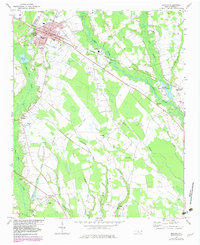
1974 Map of Maxton
USGS Topo · Published 1982About this map
Maxton serves as a significant rail and educational hub in this Robeson County landscape, marked by the presence of the Carolina Military Academy and the junction of the Seaboard Coast Line. The town's grid is dense with local institutions like St Pauls Ch, St Matthews Ch, and the Dean Sch. Outside the town center, the Lumber River and its intricate network of swamps, including Gum Swamp and Watering Hole Swamp, define the rural character of the area.
Find a feature on this map
52 named features on this map. Tap any name to fly to it.
Don’t see what you’re looking for? This feature index may not catch every label — zoom into the map to look around manually.
Map Details
Editions of this 1974 Maxton Map
2 editions found
Other maps of this area

1949 · Laurinburg
USGS Topo · 1:24,000

1949 · Wakulla
USGS Topo · 1:24,000

1949 · Laurinburg
USGS Topo · 1:62,500

1953 · Florence
USGS Topo · 1:250,000

1954 · Florence
USGS Topo · 1:250,000

1957 · Laurinburg
USGS Topo · 1:24,000

1971 · Minturn
USGS Topo · 1:24,000

1971 · Johns
USGS Topo · 1:24,000

1972 · Pembroke
USGS Topo · 1:24,000
1972 · Rowland
USGS Topo · 1:24,000