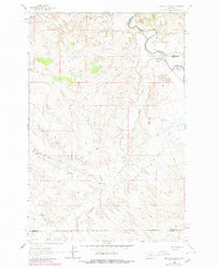
1962 Map of Maxwell Ranch
USGS Topo · Published 1980About this map
The Musselshell River carves a sharp, meandering path through the northern reaches of this central Montana landscape, marking a triple-county juncture where Petroleum, Garfield, and Rosebud Counties meet. Historically tied to the open-range ranching era, the area is anchored by the Maxwell Ranch and a network of drainage systems including North Willow Creek and Mud Springs Creek. This 1962 survey reveals a terrain defined by its complex coulees, such as Dutton Coulee and Circle Bar Coulee, which provided natural shelter and water for cattle in a semi-arid environment. The presence of a Pipeline and a solitary Drill Hole reflects the mid-century expansion of mineral exploration and utility infrastructure across the high plains. The map's layout demonstrates the intersection of natural river boundaries with the rigid township and range lines of the public land survey system.
Find a feature on this map
13 named features on this map. Tap any name to fly to it.
Don’t see what you’re looking for? This feature index may not catch every label — zoom into the map to look around manually.
Map Details
Editions of this 1962 Maxwell Ranch Map
2 editions found
Other maps of this area

1954 · Forsyth
USGS Topo · 1:250,000

1954 · Roundup
USGS Topo · 1:250,000

1957 · Forsyth
USGS Topo · 1:250,000

1958 · Roundup
USGS Topo · 1:250,000

1958 · Forsyth
USGS Topo · 1:250,000

1962 · Mosby
USGS Topo · 1:24,000

1962 · Melstone NE
USGS Topo · 1:24,000

1962 · Maxwell Ranch
USGS Topo · 1:24,000

1962 · Melstone NW
USGS Topo · 1:24,000

1962 · Mosby SE
USGS Topo · 1:24,000