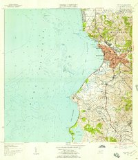
1955 Map of Mayaguez
USGS Topo · Published 1957About this map
Mayagüez and its bustling harbor define this mid-century coastal landscape, where the urban grid meets the Mona Passage. The map reveals a city in transition, balancing established sectors like Candelaria and Salud with the growing campus of the Universidad de Puerto Rico Colegio de Agricultura y Artes Mecanicas. South of the city, the land remains dominated by agricultural interests and small settlements, including Poblado Sábalos and Poblado Segundo Castillo.
Find a feature on this map
81 named features on this map. Tap any name to fly to it.
Don’t see what you’re looking for? This feature index may not catch every label — zoom into the map to look around manually.
Map Details
Editions of this 1955 Mayaguez Map
This is the sole edition of this map. No revisions or reprints were ever made.
Other maps of this area

1935 · Puerto Real
USGS Topo · 1:25,000

1937 · San German
USGS Topo · 1:25,000

1937 · Puerto Real
USGS Topo · 1:25,000

1938 · Alto Sano
USGS Topo · 1:20,000

1939 · Mayaguez
USGS Topo · 1:30,000

1941 · Rincon
USGS Topo · 1:30,000

1941 · San German
USGS Topo · 1:30,000

1941 · Puerto Real
USGS Topo · 1:30,000

1941 · Rincon
USGS Topo · 1:30,000

1941 · Rosario
USGS Topo · 1:30,000