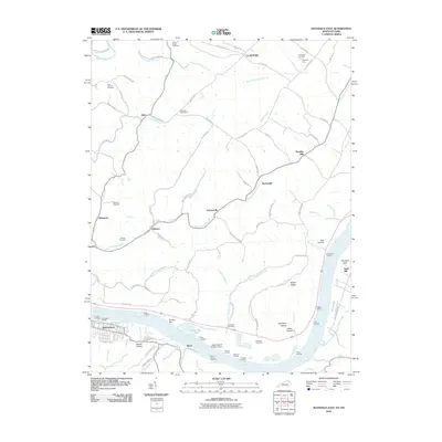
2010 Map of Maysville East
USGS Topo · Published 2010About this map
The Ohio River forms a wide, sweeping boundary between Kentucky and Ohio, serving as the focal point for riverbank commerce and industrial activity. Along its southern shore, the community of Maysville sits west of several named landings and river features, including Brooks Bar and the industrial Stuart Ash Pit Number 8 Dam. North across the water, the landscape rises into a network of creeks and ridges, where small settlements like Hiett, Clayton, and Evertonville are connected by rural routes such as Ripley Pike and Clayton Pike.
Find a feature on this map
93 named features on this map. Tap any name to fly to it.
Don’t see what you’re looking for? This feature index may not catch every label — zoom into the map to look around manually.
Map Details
Editions of this 2010 Maysville East Map
This is the sole edition of this map. No revisions or reprints were ever made.
Other maps of this area

1915 · Maysville
USGS Topo · 1:62,500

1918 · Seaman
USGS Topo · 1:62,500

1919 · Maysville
USGS Topo · 1:62,500

1928 · Higginsport
USGS Topo · 1:48,000

1929 · Springdale
USGS Topo · 1:48,000

1931 · Higginsport
USGS Topo · 1:62,500

1935 · Springdale
USGS Topo · 1:62,500

1952 · Maysville East
USGS Topo · 1:24,000

1952 · Maysville West
USGS Topo · 1:24,000
1952 · Orangeburg
USGS Topo · 1:24,000