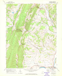
1967 Map of Maysville
USGS Topo · Published 1972About this map
Knobly Mountain and New Creek Mountain dominate this Potomac Highlands landscape, separated by the narrow corridors of Kline Gap and Mays Gap. The 1967 survey captures the rural layout of Grant County, where the settlement of Maysville sits at a crossroads along the North Fork Lunice Creek. Further south, the map details the outskirts of Petersburg as it meets the South Br Potomac, showing a mix of community landmarks like Fort Hill and the Drive-in Theater. This era reveals a balance of forest conservation within the Monongahela National Forest and local industry at the Quarry. Genealogists will find value in the placement of rural houses of worship such as Harmony Ch and Mt Hebron Ch, alongside the South Branch Memorial Gardens.
Find a feature on this map
39 named features on this map. Tap any name to fly to it.
Don’t see what you’re looking for? This feature index may not catch every label — zoom into the map to look around manually.
Map Details
Editions of this 1967 Maysville Map
3 editions found
Other maps of this area

1892 · Franklin
USGS Topo · 1:125,000

1895 · Piedmont
USGS Topo · 1:125,000

1896 · Franklin
USGS Topo · 1:125,000

1916 · Davis
USGS Topo · 1:48,000

1918 · Davis
USGS Topo · 1:62,500

1919 · Davis
USGS Topo · 1:62,500

1920 · Davis
USGS Topo · 1:48,000

1920 · Petersburg
USGS Topo · 1:48,000

1920 · Onego
USGS Topo · 1:62,500

1921 · Petersburg
USGS Topo · 1:48,000