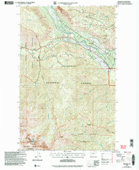
2002 Map of Mazama
USGS Topo · Published 2006About this map
Mazama serves as the focal point of this high-country landscape, positioned along the banks of the Methow River where it meets Early Winters Creek. The map documents the northern reaches of the Okanogan National Forest, transitioning into the protected Lake Chelan Sawtooth Wilderness to the south. Notable elevations like McKinney Mountain, Flagg Mountain, and Storey Peak define the horizon, while the dramatic Goat Wall rises above the valley floor. Evidence of the area's resource history appears through scattered Prospect and Adit markings near Spokane Gulch. The North Cascades Scenic Highway winds through the valley, providing the primary access corridor for this alpine environment, while numerous drainages such as Boulder Creek and Wolf Creek feed the central river system from the surrounding ridges.
Find a feature on this map
52 named features on this map. Tap any name to fly to it.
Don’t see what you’re looking for? This feature index may not catch every label — zoom into the map to look around manually.
Map Details
Editions of this 2002 Mazama Map
This is the sole edition of this map. No revisions or reprints were ever made.
Other maps of this area

1899 · Methow
USGS Topo · 1:125,000

1901 · Methow
USGS Topo · 1:125,000

1902 · Stehekin
USGS Topo · 1:125,000

1904 · Stehekin
USGS Topo · 1:125,000

1920 · Slate Pass
USGS Topo · 1:125,000

1955 · Concrete
USGS Topo · 1:250,000

1958 · Concrete
USGS Topo · 1:250,000

1962 · Concrete
USGS Topo · 1:250,000

1962 · Mazama
USGS Topo · 1:62,500

1963 · Silver Star Mtn.
USGS Topo · 1:24,000