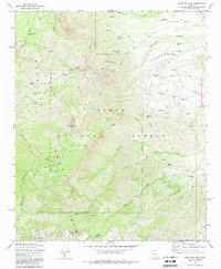
1972 Map of Mazatzal Peak
USGS Topo · Published 1979About this map
Mazatzal Peak dominates this central portion of the Mazatzal Mountains, a high-relief landscape within the Tonto National Forest defined by its system of springs and pack trails. The 1972 survey records a network of vital water sources in an otherwise arid environment, including Eisenhower Spring, Boone Moore Spring, and several remote catchments like Suicide Tank No 2. Small, isolated campsites such as Chilson Camp and Windsor Camp are positioned along these trails, suggesting the area's continued use as a high-elevation backcountry refuge. The map illustrates the convergence of Gila, Yavapai, and Maricopa counties atop the ridges. Notable human landmarks are sparse but significant for local history, specifically a lone Grave located near the headwaters of Deer Creek, marking the intersection of wilderness travel and early mountain life.
Find a feature on this map
69 named features on this map. Tap any name to fly to it.
Don’t see what you’re looking for? This feature index may not catch every label — zoom into the map to look around manually.
Map Details
Editions of this 1972 Mazatzal Peak Map
3 editions found
Other maps of this area

1887 · Verde
USGS Topo · 1:250,000

1892 · Verde
USGS Topo · 1:250,000

1907 · Roosevelt
USGS Topo · 1:125,000

1909 · Four Peaks
USGS Topo · 1:125,000

1912 · Roosevelt
USGS Topo · 1:125,000

1929 · Turret Peak
USGS Topo · 1:125,000

1930 · Cave Creek
USGS Topo · 1:125,000

1933 · Turret Peak
USGS Topo · 1:125,000

1936 · Payson
USGS Topo · 1:48,000

1939 · Cave Creek
USGS Topo · 1:125,000