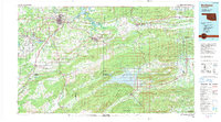
1991 Map of Mc Alester
USGS Topo · Published 1991About this map
McAlester and its surrounding coal-mining heritage dominate this landscape, which transitions from the urban center and the State Penitentiary into the complex ridges of the Sans Bois Mountains and Kiamichi Mountains. The map documents the extensive presence of the U S Army Ammunition Depot to the west, while the eastern reaches are defined by the rising waters of Sardis Lake and the natural beauty of Robbers Cave State Park.
Find a feature on this map
89 named features on this map. Tap any name to fly to it.
Don’t see what you’re looking for? This feature index may not catch every label — zoom into the map to look around manually.
Map Details
Editions of this 1991 Mc Alester Map
This is the sole edition of this map. No revisions or reprints were ever made.
Other maps of this area

1896 · Coalgate
USGS Topo · 1:125,000

1898 · McAlester
USGS Topo · 1:125,000

1899 · Coalgate
USGS Topo · 1:125,000

1899 · Atoka
USGS Topo · 1:125,000

1900 · Sansbois
USGS Topo · 1:125,000

1900 · Canadian
USGS Topo · 1:125,000

1900 · Wewoka
USGS Topo · 1:125,000

1900 · Atoka
USGS Topo · 1:125,000

1900 · Sallisaw
USGS Topo · 1:125,000

1900 · Coalgate
USGS Topo · 1:125,000