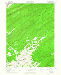
1963 Map of Mc Alevys Fort
USGS Topo · Published 1965About this map
Standing Stone Creek carves a path through the ridge-and-valley landscape of Central Pennsylvania, anchoring the small settlements and early industrial sites of northern Huntingdon County. In the early 1960s, the village of McAlevys Fort remained a focal point at the junction of several mountain roads, supported by the nearby Ennisville and institutional landmarks like the Jackson-Miller Sch, St Stephens Ch, and White Ch. The map highlights a region transitioning from its iron-making past to a focus on forest conservation and research, evidenced by the presence of Greenwood Furnace and The PA State Univ Exper Forest.
Find a feature on this map
64 named features on this map. Tap any name to fly to it.
Don’t see what you’re looking for? This feature index may not catch every label — zoom into the map to look around manually.
Map Details
Editions of this 1963 Mc Alevys Fort Map
4 editions found
Other maps of this area

1908 · Bellefonte
USGS Topo · 1:62,500

1909 · Bellefonte
USGS Topo · 1:62,500

1919 · Menno
USGS Topo · 1:62,500

1924 · Centre Hall
USGS Topo · 1:62,500

1924 · Lewistown
USGS Topo · 1:62,500

1927 · Lewisburg
USGS Topo · 1:62,500

1929 · Centre Hall
USGS Topo · 1:62,500

1935 · Allensville
USGS Topo · 1:62,500

1938 · Allensville
USGS Topo · 1:62,500

1943 · Lewistown
USGS Topo · 1:125,000
Featured Places
- Jackson Township, PA
- Harris Township, PA
- McAlevys Fort, Jackson Township
- Ferguson Township, PA
- Barree Township, PA