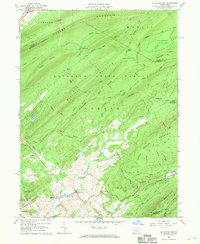
1963 Map of Mc Alevys Fort
USGS Topo · Published 1970About this map
McAlevys Fort sits at the junction of several mountain-fed waterways, anchoring a valley defined by the steep rises of Tussey Mountain and Broad Mountain. The 1963 survey reveals a landscape where conservation and academic research dominate the surrounding ridges, with The PA State Univ Exper Forest and Rothrock State Forest covering large tracts of the terrain. Local history is evident in the cluster of civic sites near the confluence of Standing Stone Creek, including the Jackson-Miller Sch and St Stephens Ch.
Find a feature on this map
51 named features on this map. Tap any name to fly to it.
Don’t see what you’re looking for? This feature index may not catch every label — zoom into the map to look around manually.
Map Details
Editions of this 1963 Mc Alevys Fort Map
4 editions found
Other maps of this area

1908 · Bellefonte
USGS Topo · 1:62,500

1909 · Bellefonte
USGS Topo · 1:62,500

1919 · Menno
USGS Topo · 1:62,500

1924 · Centre Hall
USGS Topo · 1:62,500

1924 · Lewistown
USGS Topo · 1:62,500

1927 · Lewisburg
USGS Topo · 1:62,500

1929 · Centre Hall
USGS Topo · 1:62,500

1935 · Allensville
USGS Topo · 1:62,500

1938 · Allensville
USGS Topo · 1:62,500

1943 · Lewistown
USGS Topo · 1:125,000
Featured Places
- Jackson Township, PA
- Harris Township, PA
- McAlevys Fort, Jackson Township
- Ferguson Township, PA
- Barree Township, PA