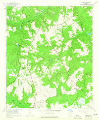
1964 Map of Mc Bean
USGS Topo · Published 1965About this map
McBean sits at the junction of the Central of Georgia railroad and the northern boundary of Burke County, where the landscape is defined by the winding course of McBean Creek. This mid-1960s survey illustrates a rural Georgia community shaped by its waterways and rail lines, with settlements like Greens Cut and Shell Bluff serving as local hubs. The area is dotted with numerous family-named burial grounds and churches, such as Crockett Cem, Mixon Cem, and Palmer Grove Ch, which provide valuable location data for genealogists and local historians.
Find a feature on this map
43 named features on this map. Tap any name to fly to it.
Don’t see what you’re looking for? This feature index may not catch every label — zoom into the map to look around manually.
Map Details
Editions of this 1964 Mc Bean Map
2 editions found
Other maps of this area

1919 · Gough
USGS Topo · 1:62,500

1920 · Greens Cut
USGS Topo · 1:62,500

1921 · Augusta
USGS Topo · 1:62,500

1922 · Hephzibah
USGS Topo · 1:62,500

1943 · Greens Cut
USGS Topo · 1:62,500

1943 · Augusta East
USGS Topo · 1:125,000

1943 · Augusta
USGS Topo · 1:62,500

1948 · Hephzibah
USGS Topo · 1:62,500

1948 · Gough
USGS Topo · 1:62,500
1950 · Hephzibah
USGS Topo · 1:24,000