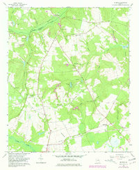
1964 Map of Mc Bean
USGS Topo · Published 1981About this map
The boundary between Richmond and Burke counties is defined by the winding course of Mc Bean Creek, which dominates the northern landscape near the settlement of Mc Bean. This 1960s era survey highlights a rural Georgia landscape transitioning through land use, marked by numerous Claypit operations and the Central of Georgia railroad corridor. The area is dense with family and community history, evidenced by a high concentration of small burial grounds like Cosnahan Cem, Knight Cem, and Mixon Cem.
Find a feature on this map
35 named features on this map. Tap any name to fly to it.
Don’t see what you’re looking for? This feature index may not catch every label — zoom into the map to look around manually.
Map Details
Editions of this 1964 Mc Bean Map
2 editions found
Other maps of this area

1919 · Gough
USGS Topo · 1:62,500

1920 · Greens Cut
USGS Topo · 1:62,500

1921 · Augusta
USGS Topo · 1:62,500

1922 · Hephzibah
USGS Topo · 1:62,500

1943 · Greens Cut
USGS Topo · 1:62,500

1943 · Augusta East
USGS Topo · 1:125,000

1943 · Augusta
USGS Topo · 1:62,500

1948 · Hephzibah
USGS Topo · 1:62,500

1948 · Gough
USGS Topo · 1:62,500
1950 · Hephzibah
USGS Topo · 1:24,000