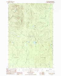
1986 Map of Mc Clusky Lake
USGS Topo · Published 1986About this map
Pennington Mountain dominates the northwestern corner of this remote Aroostook County landscape, its heights capped by a Lookout Tower that overlooks a vast network of timberlands and drainage basins. Surveyed in the mid-1980s, the terrain is defined by its complex hydrology, where McClusky Lake and Silver Lake are fed and drained by a dense web of waterways including Middle Branch Brook and Dunn Brook. The map reveals the industrial and topographical character of the northern Maine woods, structured by the township and range lines of T 15 R 6 W E L S and T 15 R 5 W E L S. Local landmarks like Goddard Ridge and Joe Dubay Brook provide specific points of reference for those tracing historical land use, while a lone Gravel Pit indicates localized resource extraction amidst the ridges and wetlands.
Find a feature on this map
19 named features on this map. Tap any name to fly to it.
Don’t see what you’re looking for? This feature index may not catch every label — zoom into the map to look around manually.
Map Details
Editions of this 1986 Mc Clusky Lake Map
This is the sole edition of this map. No revisions or reprints were ever made.
Other maps of this area

1927 · Square Lake
USGS Topo · 1:48,000

1928 · Eagle Lake
USGS Topo · 1:48,000

1928 · Winterville
USGS Topo · 1:48,000

1929 · Portage
USGS Topo · 1:62,500

1931 · Square Lake
USGS Topo · 1:62,500

1931 · Eagle Lake
USGS Topo · 1:62,500

1931 · Portage
USGS Topo · 1:62,500

1931 · Winterville
USGS Topo · 1:62,500

1953 · Square Lake
USGS Topo · 1:62,500

1953 · Portage
USGS Topo · 1:62,500