
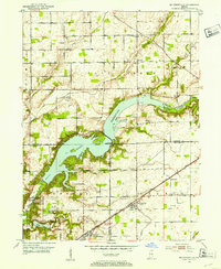
1952 Map of Mc Cordsville
USGS Topo · Published 1953About this map
Geist Reservoir dominates this Central Indiana landscape, its sprawling waters backed up behind the Spillway 785 along Fall Creek. This mid-century survey captures the region as it transitioned from a predominantly rural agricultural district into an area shaped by large-scale water management and residential development. Along the southern edge, the influence of Fort Benjamin Harrison and the New York Central and St Louis RR is evident, anchoring settlements like McCordsville and Oaklandon.
Find a feature on this map
58 named features on this map. Tap any name to fly to it.
Don’t see what you’re looking for? This feature index may not catch every label — zoom into the map to look around manually.
Map Details
Editions of this 1952 Mc Cordsville Map
2 editions found
Other maps of this area

1948 · Indianapolis East
USGS Topo · 1:24,000

1952 · Cumberland
USGS Topo · 1:24,000

1952 · Greenfield
USGS Topo · 1:24,000

1952 · Fishers
USGS Topo · 1:24,000

1952 · Ingalls
USGS Topo · 1:24,000

1953 · Lapel
USGS Topo · 1:24,000

1953 · Riverwood
USGS Topo · 1:24,000

1953 · Noblesville
USGS Topo · 1:24,000

1953 · Cincinnati
USGS Topo · 1:250,000

1953 · Danville
USGS Topo · 1:250,000