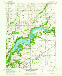
1962 Map of Mc Cordsville
USGS Topo · Published 1963About this map
Geist Reservoir dominates this landscape on the border of Hamilton, Marion, and Hancock Counties, reflecting a period of significant hydraulic and residential development in central Indiana. The sprawling reservoir is surrounded by growing subdivisions like Hawthorn Hills and Luxhaven, while the established rail corridor of the New York Central anchors the town of McCordsville to the southeast. To the southwest, a portion of the Fort Benjamin Harrison Military Reservation sits adjacent to Indian Lake, marking the transition toward the Indianapolis metropolitan area.
Find a feature on this map
49 named features on this map. Tap any name to fly to it.
Don’t see what you’re looking for? This feature index may not catch every label — zoom into the map to look around manually.
Map Details
Editions of this 1962 Mc Cordsville Map
3 editions found
Other maps of this area

1948 · Indianapolis East
USGS Topo · 1:24,000

1952 · Cumberland
USGS Topo · 1:24,000

1952 · Greenfield
USGS Topo · 1:24,000

1952 · Fishers
USGS Topo · 1:24,000

1952 · Ingalls
USGS Topo · 1:24,000

1952 · Mc Cordsville
USGS Topo · 1:24,000

1953 · Lapel
USGS Topo · 1:24,000

1953 · Riverwood
USGS Topo · 1:24,000

1953 · Noblesville
USGS Topo · 1:24,000

1953 · Cincinnati
USGS Topo · 1:250,000