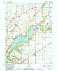
1962 Map of Mc Cordsville
USGS Topo · Published 1991About this map
Geist Reservoir dominates the central landscape of this 1962 survey, which covers the corners of Hamilton, Marion, and Hancock counties during a period of suburban transition. The map captures the interface between traditional agricultural life and emerging recreation, visible in the proximity of family burial grounds like Lowery Cem and Kinnamon Cem to newer developments such as Hawthorn Hills and the Indianapolis Sailing Club.
Find a feature on this map
52 named features on this map. Tap any name to fly to it.
Don’t see what you’re looking for? This feature index may not catch every label — zoom into the map to look around manually.
Map Details
Editions of this 1962 Mc Cordsville Map
3 editions found
Other maps of this area

1948 · Indianapolis East
USGS Topo · 1:24,000

1952 · Cumberland
USGS Topo · 1:24,000

1952 · Greenfield
USGS Topo · 1:24,000

1952 · Fishers
USGS Topo · 1:24,000

1952 · Ingalls
USGS Topo · 1:24,000

1952 · Mc Cordsville
USGS Topo · 1:24,000

1953 · Lapel
USGS Topo · 1:24,000

1953 · Riverwood
USGS Topo · 1:24,000

1953 · Noblesville
USGS Topo · 1:24,000

1953 · Cincinnati
USGS Topo · 1:250,000