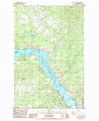
1985 Map of Mc Coy Lake
USGS Topo · Published 1985About this map
The Spokane Indian Reservation dominates the eastern half of this 1980s landscape, where the confluence of the Spokane River and Franklin D Roosevelt Lake creates a complex shoreline. This area serves as a primary hub for both industrial extraction and recreation, evidenced by the proximity of the Spokane Molybdenum Mine and Sherwood Mine to the protected waters of the National Recreation Area. Small agrarian settlements like Pitney and Howard appear as quiet clusters among the ridges, while the western side of the lake features landmarks like Tamarack Flat and Lilienthal Mtn. The terrain is marked by steep transitions from the Enterprise Valley down to the water’s edge, where a Boat Ramp and the Porcupine Bay Campground provide access to the river system. A small Cem near the lake's edge offers a tangible link for genealogists researching families from the Egypt area.
Find a feature on this map
35 named features on this map. Tap any name to fly to it.
Don’t see what you’re looking for? This feature index may not catch every label — zoom into the map to look around manually.
Map Details
Editions of this 1985 Mc Coy Lake Map
This is the sole edition of this map. No revisions or reprints were ever made.
Other maps of this area

1948 · Hunters
USGS Topo · 1:62,500

1948 · Wilmont Creek
USGS Topo · 1:62,500

1948 · Lincoln
USGS Topo · 1:62,500

1948 · Turtle Lake
USGS Topo · 1:62,500

1950 · Lincoln
USGS Topo · 1:62,500

1950 · Turtle Lake
USGS Topo · 1:62,500

1950 · Wilmont Creek
USGS Topo · 1:62,500

1950 · Hunters
USGS Topo · 1:62,500

1953 · Ritzville
USGS Topo · 1:250,000

1954 · Okanogan
USGS Topo · 1:250,000