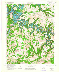
1963 Map of Mc Daniels
USGS Topo · Published 1964About this map
The Rough River Reservoir snakes through the landscape on this 1960s survey, illustrating the significant impact of the Rough River Dam on the topography of Breckinridge and Grayson Counties. This era of water management is clearly visible in the flooded valley where the North Fork and Rough River meet, creating complex shorelines around former high points like Hinton Hills and Cannons Point.
Find a feature on this map
54 named features on this map. Tap any name to fly to it.
Don’t see what you’re looking for? This feature index may not catch every label — zoom into the map to look around manually.
Map Details
Editions of this 1963 Mc Daniels Map
3 editions found
Other maps of this area

1922 · Leitchfield
USGS Topo · 1:48,000

1925 · Spring Lick
USGS Topo · 1:62,500

1925 · Leitchfield
USGS Topo · 1:62,500

1932 · Fordsville
USGS Topo · 1:62,500

1953 · Custer
USGS Topo · 1:24,000

1953 · Mc Daniels
USGS Topo · 1:24,000

1953 · Kingswood
USGS Topo · 1:24,000

1953 · Falls Of Rough
USGS Topo · 1:24,000
1953 · Glen Dean
USGS Topo · 1:24,000

1954 · Evansville
USGS Topo · 1:250,000