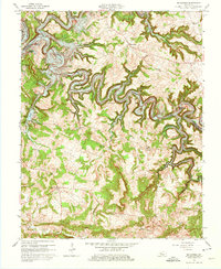
1963 Map of Mc Daniels
USGS Topo · Published 1975About this map
The Rough River Reservoir snakes through this 1963 landscape, defining the topography where the Breckinridge and Grayson county lines meet. The reservoir’s irregular shoreline creates numerous named points and valleys, including Cannons Point and Indian Valley, which contrasts with the traditional agricultural and timber patterns of the surrounding uplands. Small rural hubs such as McDaniels and Duff anchor the social landscape, supported by country institutions like the Pilgrim Ch and Johnson Sch.
Find a feature on this map
48 named features on this map. Tap any name to fly to it.
Don’t see what you’re looking for? This feature index may not catch every label — zoom into the map to look around manually.
Map Details
Editions of this 1963 Mc Daniels Map
3 editions found
Other maps of this area

1922 · Leitchfield
USGS Topo · 1:48,000

1925 · Spring Lick
USGS Topo · 1:62,500

1925 · Leitchfield
USGS Topo · 1:62,500

1932 · Fordsville
USGS Topo · 1:62,500

1953 · Custer
USGS Topo · 1:24,000

1953 · Mc Daniels
USGS Topo · 1:24,000

1953 · Kingswood
USGS Topo · 1:24,000

1953 · Falls Of Rough
USGS Topo · 1:24,000
1953 · Glen Dean
USGS Topo · 1:24,000

1954 · Evansville
USGS Topo · 1:250,000