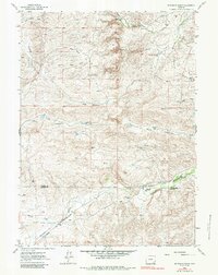
1962 Map of Mc Donald Ranch
USGS Topo · Published 1984About this map
The rugged drainage systems of the Richeau Hills define this high-plains landscape where the Platte Co Laramie Co line divides the terrain. Cattle ranching and remote schoolhouses anchor the local geography in the early 1960s, with legacy properties like Diamond Ranch and Mc Donald Ranch positioned along the essential watercourses. The network of seasonal drainages, including North Steer Draw and South Steer Draw, reveals how the land was managed for livestock before modern intensification. Isolated landmarks such as the Mc Donald Sch and the settlement at Duval reflect the sparse, community-centered layout of the era. The mapping of Chugwater Creek and Richeau Creek provides a clear view of the natural hydrology that dictated settlement patterns across this section of Wyoming.
Find a feature on this map
22 named features on this map. Tap any name to fly to it.
Don’t see what you’re looking for? This feature index may not catch every label — zoom into the map to look around manually.
Map Details
Editions of this 1962 Mc Donald Ranch Map
3 editions found
Other maps of this area

1953 · Natwick SW
USGS Topo · 1:24,000

1953 · Double L Ranch
USGS Topo · 1:24,000

1953 · Richeau Hills
USGS Topo · 1:24,000

1954 · Cheyenne
USGS Topo · 1:250,000

1958 · Cheyenne
USGS Topo · 1:250,000

1962 · Farthing
USGS Topo · 1:24,000

1962 · Delano Ranch
USGS Topo · 1:24,000

1962 · Bristol Ridge
USGS Topo · 1:24,000

1962 · Hirsig Ranch
USGS Topo · 1:24,000

1962 · Mc Donald Ranch
USGS Topo · 1:24,000