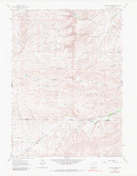
1962 Map of McDonald Ranch
USGS Topo · Published 1984About this map
The Colorado and Southern railroad cuts across this high plains landscape at the border of Platte and Laramie counties, following the winding course of the Creek through the southeastern Wyoming ranchlands. The area is defined by the cattle-raising heritage of the mid-20th century, anchored by family-named holdings such as McDonald Ranch, Diamond Ranch, and the Wedemeyer Ranch. Small rural infrastructure is evident at McDonald Sch, a local landmark for the surrounding ranching families. The terrain is a network of drainage systems including North Chugwater Creek, Richeau Creek, and various seasonal draws like Steer Draw and Duval Draw. Numerous springs, such as Richeau Spring, indicate the vital water sources required to sustain livestock in this environment, while the tiny settlement of Parson sits in the northern reaches of the quadrangle.
Find a feature on this map
21 named features on this map. Tap any name to fly to it.
Don’t see what you’re looking for? This feature index may not catch every label — zoom into the map to look around manually.
Map Details
Editions of this 1962 McDonald Ranch Map
3 editions found
Other maps of this area

1953 · Natwick SW
USGS Topo · 1:24,000

1953 · Double L Ranch
USGS Topo · 1:24,000

1953 · Richeau Hills
USGS Topo · 1:24,000

1954 · Cheyenne
USGS Topo · 1:250,000

1958 · Cheyenne
USGS Topo · 1:250,000

1962 · Farthing
USGS Topo · 1:24,000

1962 · Delano Ranch
USGS Topo · 1:24,000

1962 · Bristol Ridge
USGS Topo · 1:24,000

1962 · Hirsig Ranch
USGS Topo · 1:24,000

1962 · Mc Donald Ranch
USGS Topo · 1:24,000