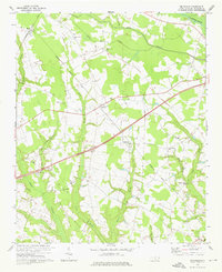
1972 Map of Mc Donald
USGS Topo · Published 1976About this map
The Lumber River forms the northern boundary of this Robeson County landscape, winding through a network of wetlands and tributaries that define the local topography. Small rural communities like McDonald and Elrod are anchored by an extensive system of country churches and community centers, including Pleasant Grove Ch, Back Swamp Ch, and New Bethel Ch. The presence of Green Grove Sch and numerous cemeteries suggests a well-established social fabric tied to the surrounding farmland and the wet lowlands of Back Swamp and Horn Camp Swp.
Find a feature on this map
27 named features on this map. Tap any name to fly to it.
Don’t see what you’re looking for? This feature index may not catch every label — zoom into the map to look around manually.
Map Details
Editions of this 1972 Mc Donald Map
This is the sole edition of this map. No revisions or reprints were ever made.
Other maps of this area

1943 · Pages Mill
USGS Topo · 1:62,500

1953 · Florence
USGS Topo · 1:250,000

1954 · Florence
USGS Topo · 1:250,000

1960 · Dillon East
USGS Topo · 1:24,000

1962 · Fairmont
USGS Topo · 1:24,000

1962 · Gaddysville
USGS Topo · 1:24,000

1962 · Fair Bluff
USGS Topo · 1:62,500

1972 · Northwest Lumberton
USGS Topo · 1:24,000

1972 · Southwest Lumberton
USGS Topo · 1:24,000

1972 · Pembroke
USGS Topo · 1:24,000