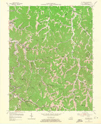
1954 Map of Mc Dowell
USGS Topo · Published 1971About this map
The Chesapeake and Ohio railroad corridor anchors this survey of eastern Kentucky, tracing the winding path of Beaver Creek through a landscape defined by narrow hollows and numerous local schools. In the early 1950s, the region's coal-based economy is evident at Drift and Price, where a Tipple and various mine-related structures sit alongside the rail lines. Small settlements like McDowell and Hi Hat serve as centers for these dispersed mountain communities, which supported an exceptional density of rural educational buildings, including the Mouth of Branham Creek Sch and Neck Branch Sch.
Find a feature on this map
97 named features on this map. Tap any name to fly to it.
Don’t see what you’re looking for? This feature index may not catch every label — zoom into the map to look around manually.
Map Details
Editions of this 1954 Mc Dowell Map
Other maps of this area

1886 · Prestonsburg
USGS Topo · 1:125,000

1890 · Whitesburg
USGS Topo · 1:125,000

1892 · Whitesburg
USGS Topo · 1:125,000

1892 · Prestonsburg
USGS Topo · 1:125,000

1912 · Hindman
USGS Topo · 1:48,000

1914 · Laynesville
USGS Topo · 1:48,000

1914 · Vergie
USGS Topo · 1:48,000

1915 · Prestonsburg
USGS Topo · 1:62,500

1915 · Hindman
USGS Topo · 1:62,500

1916 · Harold
USGS Topo · 1:62,500