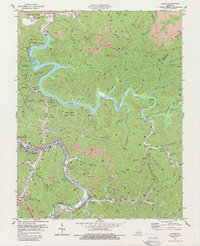
1978 Map of Lancer
USGS Topo · Published 1988About this map
The Levisa Fork and its complex valley system dominate this late-1970s landscape, where industrial extraction and recreational development exist side-by-side. The presence of numerous strip mines along the ridgelines of Daniels Fork and Right Fork contrasts with the established residential pockets at Lancer, Endicott, and Emma. Family history is preserved in several scattered burial grounds, including the Mayo Cem, while the spiritual life of the area is anchored by Philadelphia Ch and Trimble Chapel.
Find a feature on this map
74 named features on this map. Tap any name to fly to it.
Don’t see what you’re looking for? This feature index may not catch every label — zoom into the map to look around manually.
Map Details
Editions of this 1978 Lancer Map
Other maps of this area

1886 · Prestonsburg
USGS Topo · 1:125,000

1892 · Prestonsburg
USGS Topo · 1:125,000

1914 · Laynesville
USGS Topo · 1:48,000

1914 · Inez
USGS Topo · 1:48,000

1915 · Paintsville
USGS Topo · 1:48,000

1915 · Prestonsburg
USGS Topo · 1:62,500

1916 · Harold
USGS Topo · 1:62,500

1916 · Inez
USGS Topo · 1:62,500

1917 · Paintsville
USGS Topo · 1:62,500

1918 · Prestonsburg
USGS Topo · 1:62,500