
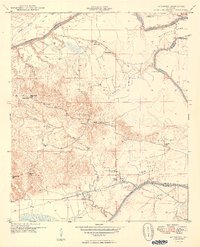
1949 Map of Mc Dowell
USGS Topo · Published 1949About this map
The Tombigbee River snakes through the landscape, defining the boundaries between Greene, Sumter, and Marengo Counties. This 1940s topography shows a rural network of small agricultural settlements and timber lands, notably around the crossroads of Belmont and the river landing at McDowell. The presence of numerous institutions like Oak Grove Sch, Bucks Chapel Sch, and St Michael Sch suggests a community structure oriented around localized schoolhouses and churches. Further inland, the Southern railroad line cuts through the southern portion of the quadrangle near Hall Creek, providing a vital connection for the movement of goods away from the river's edge. This era captures the area just as aerial photography began to modernize mapping, yet many traditional river features like the McDowell Ferry and the dramatic Twelvemile Bend remained central to local geography.
Find a feature on this map
42 named features on this map. Tap any name to fly to it.
Don’t see what you’re looking for? This feature index may not catch every label — zoom into the map to look around manually.
Map Details
Editions of this 1949 Mc Dowell Map
2 editions found
Other maps of this area

1929 · Epes
USGS Topo · 1:48,000

1932 · Epes
USGS Topo · 1:62,500

1946 · Demopolis
USGS Topo · 1:24,000

1947 · Demopolis
USGS Topo · 1:24,000

1947 · Mason Bend
USGS Topo · 1:24,000

1947 · Forkland
USGS Topo · 1:24,000

1948 · Mason Bend
USGS Topo · 1:24,000

1948 · Mc Dowell
USGS Topo · 1:24,000

1949 · Forkland
USGS Topo · 1:24,000

1953 · Montgomery
USGS Topo · 1:250,000