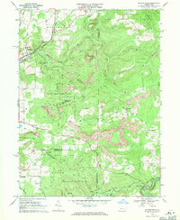
1968 Map of Mc Gees Mills
USGS Topo · Published 1971This historical map portrays the area of Mc Gees Mills in 1968, primarily covering Clearfield County as well as portions of Jefferson County and Indiana County. Featuring a scale of 1:24000, this map provides a highly detailed snapshot of the terrain, roads, buildings, counties, and historical landmarks in the Mc Gees Mills region at the time. Published in 1971, it is one of 5 known editions of this map due to revisions or reprints.
Find a feature on this map
46 named features on this map. Tap any name to fly to it.
Don’t see what you’re looking for? This feature index may not catch every label — zoom into the map to look around manually.
Map Details
Editions of this 1968 Mc Gees Mills Map
5 editions found
Historical Maps of McGees Mills Through Time
19 maps found

1929 Karthaus
Clearfield County, PA

1929 Penfield
Clearfield County, PA

1932 Karthaus
Clearfield County, PA

1932 Penfield
Clearfield County, PA

1944 Glen Richey
Clearfield County, PA

1946 Glen Richey
Clearfield County, PA

1959 Devils Elbow
Clearfield County, PA

1959 Elliott Park
Clearfield County, PA

1959 Frenchville
Clearfield County, PA

1959 Huntley
Clearfield County, PA

1959 Lecontes Mills
Clearfield County, PA

1959 Luthersburg
Clearfield County, PA

1959 Penfield
Clearfield County, PA

1959 Sabula
Clearfield County, PA

1959 The Knobs
Clearfield County, PA

1968 Mc Gees Mills
Clearfield County, PA

1993 Glen Richey
Clearfield County, PA

1993 Penfield
Clearfield County, PA

2000 Lecontes Mills
Clearfield County, PA
Featured Locations
- Banks Township, PA
- Gaskill Township, PA
- Hillman, Banks Township
- Keal Run, Banks Township
- Sidney, Banks Township