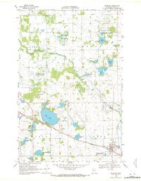
1969 Map of Mc Intosh
USGS Topo · Published 1971About this map
McIntosh serves as the primary hub for the surrounding townships of King, Knute, Lessor, and Badger in this late-1960s survey of Polk County. The landscape is defined by its numerous prairie lakes and wetlands, including Oak Lake, Frisk Lake, and Keller Lake, many of which are protected under the National Wildlife Management Area and Polk State Wildlife Management Areas. The Burlington Northern railroad cuts diagonally through the terrain, passing through McIntosh and past the Weight Station at the edge of the water.
Find a feature on this map
40 named features on this map. Tap any name to fly to it.
Don’t see what you’re looking for? This feature index may not catch every label — zoom into the map to look around manually.
Map Details
Editions of this 1969 Mc Intosh Map
3 editions found
Other maps of this area

1918 · Terrebonne
USGS Topo · 1:62,500

1919 · Grit
USGS Topo · 1:62,500

1919 · Valley
USGS Topo · 1:62,500

1952 · Grand Forks
USGS Topo · 1:250,000

1954 · Bemidji
USGS Topo · 1:250,000

1956 · Grand Forks
USGS Topo · 1:250,000

1957 · Bemidji
USGS Topo · 1:250,000

1958 · Bemidji
USGS Topo · 1:250,000

1964 · Brooks
USGS Topo · 1:24,000

1966 · Grand Forks
USGS Topo · 1:250,000