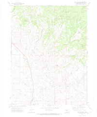
2000 Map of Mc Inturf Mesa
USGS Topo · Published 2004About this map
Routt National Forest lands dominate the northeastern corner of this 1970s landscape, where the high-altitude terrain transitions from the timbered slopes of Mc Inturf Mesa and Pinnacle Mountain down toward the drainages of Fortification Creek. The map documents a rugged interior economy of resource extraction and water management, evidenced by the presence of the Seymour Mine and Bridges Mine in the southern hills. Local industrial activity is further noted by several Drill Hole sites and a network of jeep trails providing access to remote peaks like Buck Mountain. Near the southern boundary, Ralph White Lake serves as a primary water feature in an area otherwise defined by seasonal gulches and creeks such as Little Bear Creek and Taylor Creek.
Find a feature on this map
18 named features on this map. Tap any name to fly to it.
Don’t see what you’re looking for? This feature index may not catch every label — zoom into the map to look around manually.
Map Details
Editions of this 2000 Mc Inturf Mesa Map
This is the sole edition of this map. No revisions or reprints were ever made.
Other maps of this area

1916 · Craig
USGS Topo · 1:125,000

1923 · Elkhead Creek
USGS Topo · 1:62,500

1924 · Elkhead Creek
USGS Topo · 1:62,500

1954 · Craig
USGS Topo · 1:250,000

1957 · Craig
USGS Topo · 1:250,000

1958 · Craig
USGS Topo · 1:250,000

1960 · Craig
USGS Topo · 1:250,000

1962 · Craig
USGS Topo · 1:250,000

1964 · Craig
USGS Topo · 1:250,000

1965 · Craig
USGS Topo · 1:250,000