
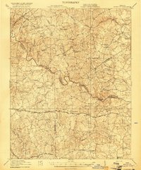
1921 Map of Mc Kenney
USGS Topo · Published 1921About this map
McKenney and Purdy anchor a landscape of intricate hydrology and early 20th-century transportation networks at the confluence of several Virginia counties. The area is defined by the winding course of the Nottoway River, where historical crossings like Laxottes Ford and Outbank Bridge suggest the connectivity of a rural agrarian economy. Significant rail corridors such as the Seaboard Air Line and the Virginian slice through the terrain, linking remote settlements like Smoky Ordinary and Adsit to larger trade hubs.
Find a feature on this map
71 named features on this map. Tap any name to fly to it.
Don’t see what you’re looking for? This feature index may not catch every label — zoom into the map to look around manually.
Map Details
Editions of this 1921 Mc Kenney Map
2 editions found
Other maps of this area

1894 · Petersburg
USGS Topo · 1:62,500

1897 · Amelia
USGS Topo · 1:125,000

1918 · Lawrenceville
USGS Topo · 1:62,500

1919 · Jarratt
USGS Topo · 1:62,500

1919 · Mc Kenney
USGS Topo · 1:48,000

1919 · White Plains
USGS Topo · 1:48,000

1919 · Emporia
USGS Topo · 1:62,500

1919 · Arringdale
USGS Topo · 1:48,000

1920 · Lawrenceville
USGS Topo · 1:48,000

1920 · White Plains
USGS Topo · 1:62,500